PROJECTS
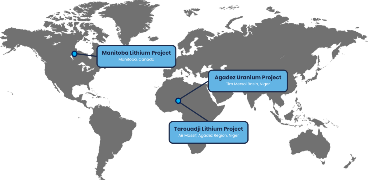
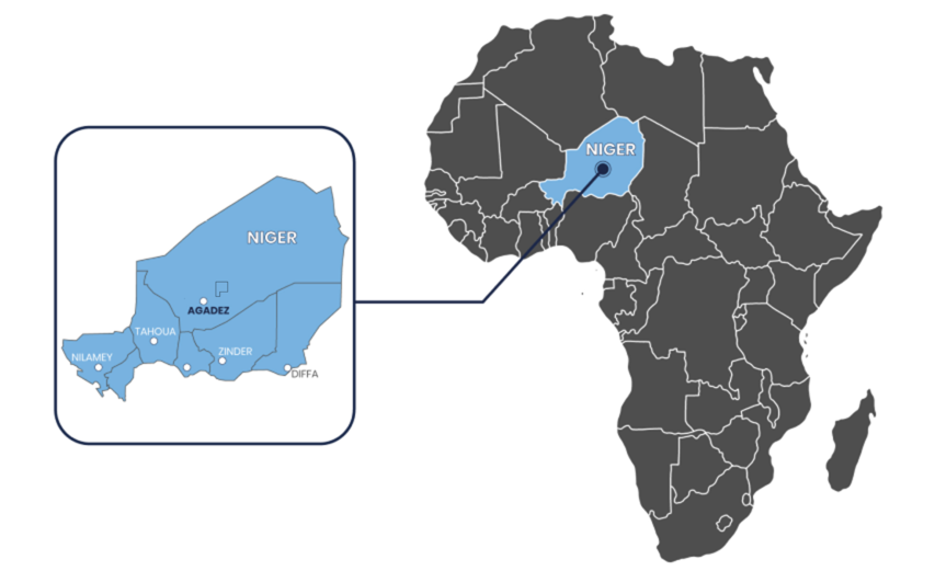
Agadez Uranium Project
Tim Mersoi Basin, Niger
An Underexplored Project in a World Class Uranium Basin

Overview

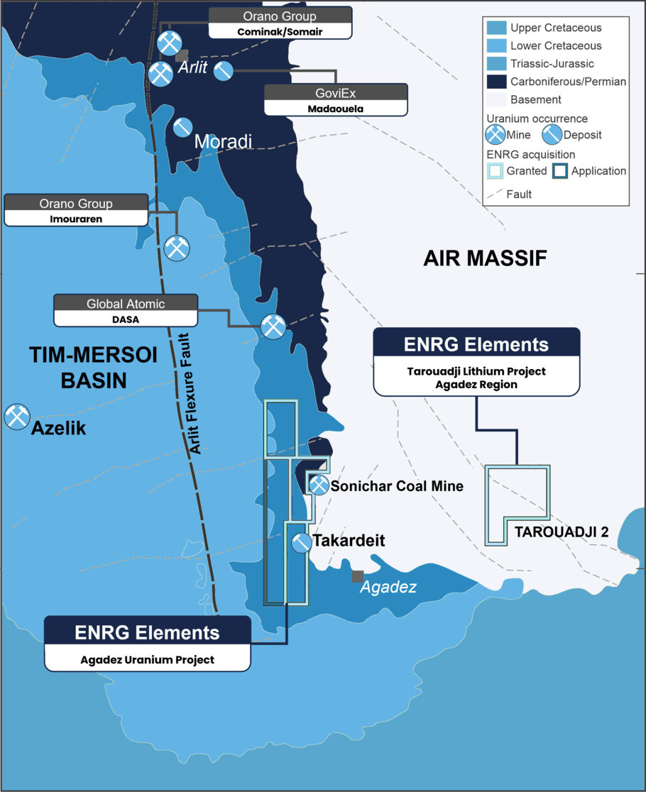
ENRG Elements Agadez Uranium Project is located in the highly prospective Tim Mersoi Basin, Niger, a mining jurisdiction with a long history of uranium production.
100% of three exploration permits (726km2) and an exploration licence application.
The Project hosts similar geology to Orano SA’s Cominak/Somair and Imouraren mines and deposits held by Global Atomic Corporation (TSE:GLO) and GoviEx Uranium (CVE:GXU).
Agadez Uranium Project Mineral Resource Estimate (MRE) updated to JORC 2012 standard, with the Takardeit deposit now containing an Inferred Resource of 31.1Mt at a grade of 315ppm eU3O8 for 21.5 million pounds (at 175ppm cut-off).
Assay results from rock chip sampling program at Agadez show 74 of 83 (89%) samples collected returning values over 500ppm eU3O8.
Rock chip assay results are outstanding, including a highest 34.3% (343,008ppm) eU3O8 (343,008ppm) and 26.1% (261,066 ppm) eU3O8 (261,066 ppm).
Takardeit Mineral Resource Estimate expected to be updated following receipt of assay results, anticipated in Q4 CY2022.
Tenements were previously acquired by Paladin Energy Ltd for AU$27M when uranium prices were ~US$45/lb(1).
ENRG acquired and reviewed historical exploration information further supports tenement prospectivity and confirms mineralization across the Agadez Uranium Project.
Niger has one of the world’s largest uranium reserves(2) and is one of the highest producers of uranium globally.
Strong Niger government and community support for new foreign investment.
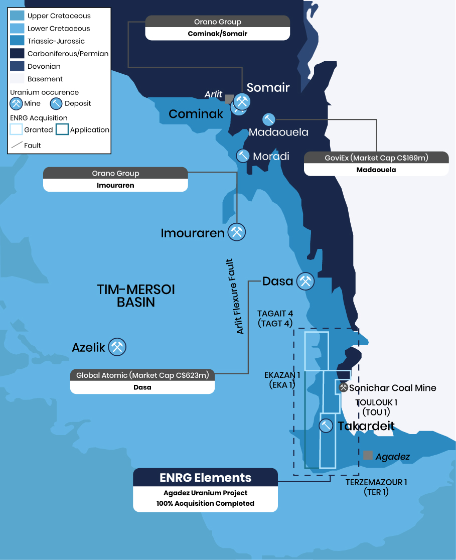
Map of ENRG Elements tenements and location in the Tim Mersoi Basin
Exploration Program Underway at Agadez
Assay Results Confirm Significant Potential
- Exploration program recently completed at Agadez comprising approximately 5,340m of rotary mud drilling and 160m of diamond core, in conjunction with a surface sampling program.
- The ~5,500m drilling program confirmed mineralisation from surface to ~40m depth and extending beyond the current Mineral Resource Estimate area.
- Mineralisation remains open in multiple directions.
- Significant downhole gamma results at Takardeit Centre, includes(3):
- KPM0048 –2m at 2,266ppm eU3O8 from 22.7m; and
- KPM0030 –2m at 1,562ppm eU3O8 from 28.2m; and
- KPM0018 -2m at 1,172ppm eU3O8 from 24.7m.
“We are very excited to announce this Mineral Resource Estimate upgrade to a total of 21.5 Mlb U3O8, which includes an increase in grade of 6.8%, and an increase in contained metal of 101%. This Resource update demonstrates the exciting potential of the Agadez Project and with a drilling program planned to commence in the coming months, we look forward to further building on this Mineral Resource Estimate at Takardeit and to identify other priority regional exploration targets within our tenement package.”
Caroline Keats
Managing Director
2011 Paladin Exploration Data
Recently Acquired Data Shows Significant Potential
- The Company reviewed recently acquired previously unannounced historical drilling information for Agadez from Paladin and confirmed the project as prospective for uranium.(4)
- The information includes geological and geophysical information, surveys, photographs, in addition to drill logs and assay results from Paladin’s 2011 drilling program.
- Of this extensive program, 31 drill holes covering 6,595m are on the leases currently controlled by ENRG.
- Significant intervals from Paladin’s drill program outside of the Takardeit resource area include:
- TOU016: 2m @ 0.17% (1,735 ppm) eU3O8 from 229.5m
- TER010: 2m @ 0.14% (1,384 ppm) eU3O8 from 48.5m
- TER008: 1m @ 0.17% (1,697 ppm) eU3O8 from 148.7m
- Substantial number of follow-up targets identified for future exploration programs
“The Results and significant intersections have confirmed Agadez as prospective for uranium and have significantly improved our geological understanding of the Project. Importantly, with potential for higher grade areas of mineralisation within the Takardeit Inferred Mineral Resource, ENRG has used this data to define and guide the exploration program which is currently underway.”
Caroline Keats
Managing Director
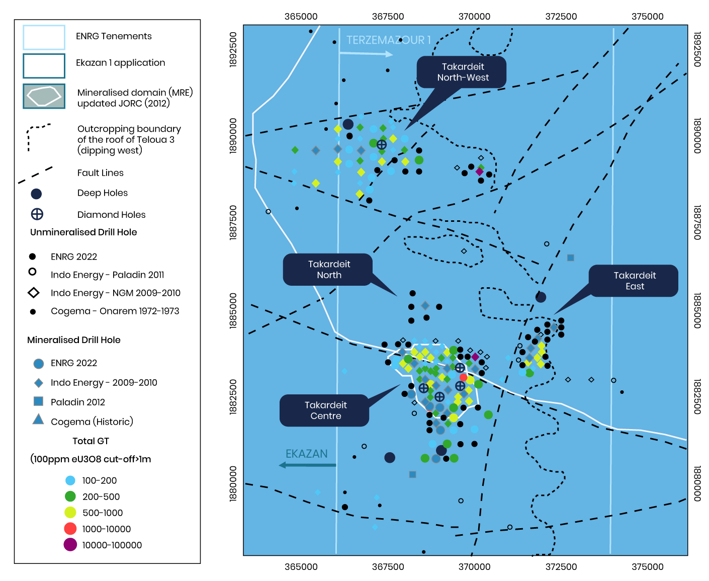
Geological map of the Permits showing the NGM and Paladin drill hole locations and main prospects
- Paladin’s drill program targeted regional identification of high-grade uranium mineralization in the Lower Carboniferous stratigraphy as well as in shallow Jurassic sediments similar to those hosting the Takardeit deposit.
- ENRG’s technical consultants identified and confirmed mineralisation potential:
- Across the tenement package; and
- For higher-grade areas within the existing Takardeit Mineral Resource (JORC (2004))(5), with mineralisation from surface to 30m.
- Economic deposits occurring along WNW and N–S trending structures are Orano’s, CNUC’s and Global Atomic’s deposits
- GoviEx’s occurs along the NW trending (N30) structure;
- Several of the major structures intersect the Agadez Uranium Project.
- Information analysed from Paladin’s exploration program will be used to inform ENRG’s future work targeting Jurassic and Carboniferous stratigraphy.
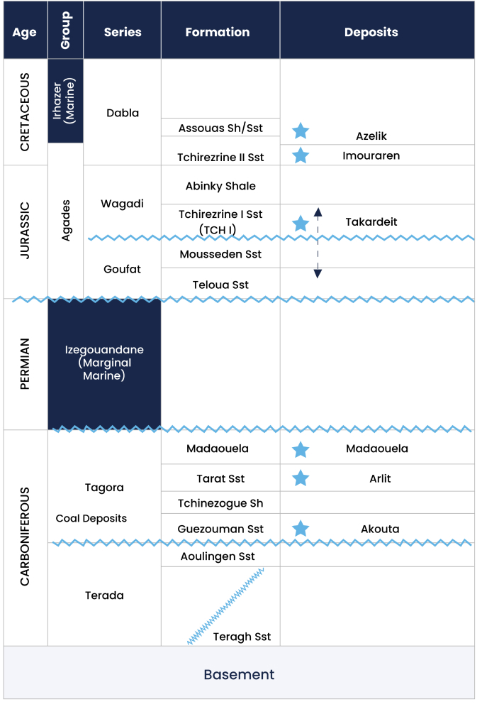
Stratigraphic column over the ENRG Elements exploration licences area and stratigraphic location of the main deposits.
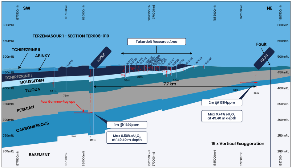
Idealized geological SW-NE section across Takardeit deposit area.
Ghanzi West Copper Project
Kalahari Copper Belt, Botsawana
Underexplored emerging world-class copper province in the Kalahari Copper Belt
Overview
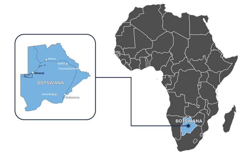
The Ghanzi-West Project is located in the Kalahari Copper Belt of Botswana, along strike from Sandfire Resources Limited’s (ASX:SFR) Motheo and A4 copper-silver projects, and in the same region as Cobre Limited’s (ASX:CBE) recent Ngami Copper Project discovery.
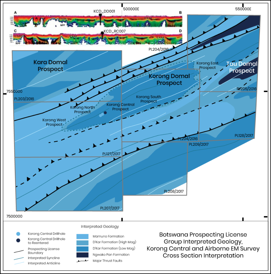
Airborne electromagnetic and gravity survey has commenced across the Kara Dome assets.
Comprises six prospecting licences over a land area of 2,630km2.
Three key targets have been identified at Ghanzi-West being:
- Kara–along regional structure from T3 deposit (~840km2)
- Korong–large Domal target (~1,091km2)
- Tau–4km from Sandfire T7 prospect.
Safe, politically stable and mining-friendly jurisdiction.
Botswana ranked 1st in Africa and 11th of 77 countries globally in overall mining investment attractiveness(1).
(1) Fraser Institute Annual Survey of Mining Companies 2020
Airborne Electromagnetic & Gravity
- Airborne electromagnetic and gravity survey being conducted across the Company’s Kara Dome assets, located in the Kalahari Copper Belt, Botswana.
- Survey aims to delineate structural domains in conductivity associated with domes, which are favourable for hosting significant economic mineralisation.
- Kara Dome is considered prospective for copper-silver mineralisation in folded transitional sediments, similar to those at Sandfire (Motheo and A4) and Khoemacau (Zone 5, Banana Zone) projects.
- The program is focused on identifying fold related anticline hinge zones and structurally controlled trap sites associated with domal structures, similar to those discovered along strike by Sandfire Resources (Motheo and A4 copper-silver projects).
- The program is expected to commence in early August, with results in Q4 CY2022.
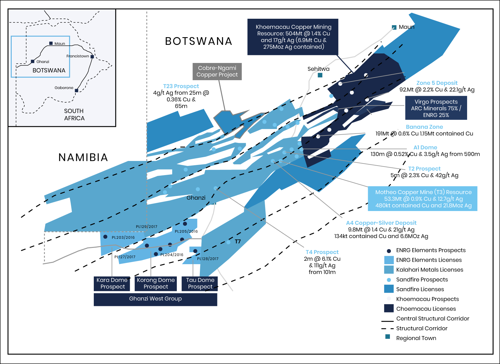
Location of ENRG Elements prospecting licences within the Kalahari Copper Belt
Horseshoe West Gold-Copper Project
Western Australia
Joint-Venture with Horseshoe Metals in Western Australia
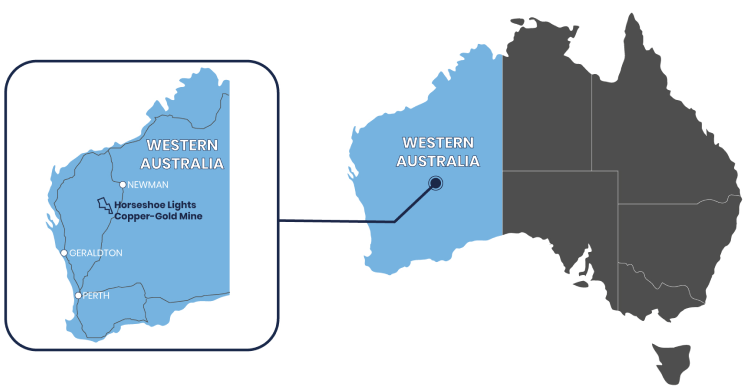
Overview
Earn-in and Joint-Venture with subsidiary of Horseshoe Metals Ltd (ASX:HOR) relating to 9 prospecting licenes, 1 exploration licence and part of a mining lease(1)
75km from Sandfire’s Degrussa Mine, located in the highly prospective and prolific (Cu-Au) Bryah Basin region in Western Australia
Tenements surround the historical high-grade copper-gold Horseshoe Lights Mine
Discovered in 1946, the mine produced ~56kt Cu (3.3Mt @ average of 1.7% Cu) and 307koz Au (average grade of 2.9g/t) up to 1994
Agreement relates to 32.4km2 of largely unexplored land surrounding the Horseshoe Lights Mine
Completed auger drilling program delineated a coherent copper-gold soil anomaly over identified airborne magnetic trends(2)
Horseshoe West Dipole-Dipole Induced Polarisation (DDIP) survey interpretation completed, with new targets identified from the processing and interpretation of the DDIP survey data(3)
(1) See Company announcement “Kopore Earns Into Horseshoe West Copper/Gold Exploration Project” on 28 January 2021.
(2) See Company announcement “Horseshoe West Soil Anomalies Identified and Botswana Licenses Renewed” on 15 November 2021.
(3) Refer to ASX Announcement “Horseshoe West Project Update” on 16 August 2022
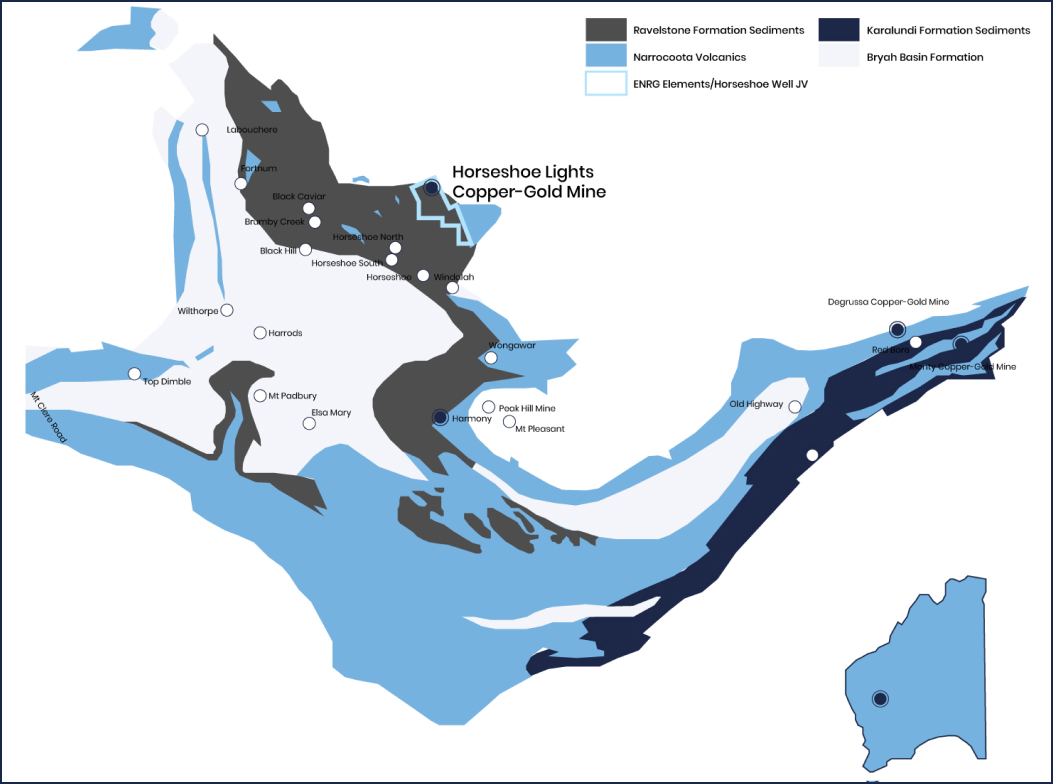
Location of ENRG Elements prospecting licences at Horseshoe Lights in Western Australia
Virgo Copper Project
Kalahari Copper Belt, Botsawana

Overview
The Virgo Project, comprises two prospecting licences (PL 135/2017 & PL 162/2017)is located in an emerging copper district in the Kalahari Copper Belt covers an area of over 210km2. The Virgo licenses lie within close proximity of larger discoveries, and in particular within 10km and 50km of the Zone 5 and Banana Zone copper projects, respectively, which are known as the two largest copper projects on the Kalahari Copper Belt.
As announced on the ASX on 25 March 2021, ENRG Elements Ltd (formerly Kopore Metals Ltd) executed a binding term sheet with ARC Minerals Limited (AIM:ARCM) (ARC) to assist with ongoing exploration at the Company’s Virgo Project in the Republic of Botswana (Transaction)1.
Pursuant to the terms of the Transaction, the Company agreed to sell 75% of the issued capital in its wholly owned subsidiary company, Alvis-Crest (Proprietary) Limited (Alvis) to ARC.
On 26 July 2021, ENRG Elements Ltd announced that it had satisfied key conditions precedent to the Transaction by entering a binding shareholders agreement and royalty deed with ARC. Closing of the transaction proceeded following receipt of Ministerial approval in Botswana, resulting in ENRG Elements retaining a 25% interest in the Virgo Project.
(1) ASX Release: Virgo Project Transaction With Arc Minerals - 25 March 2021
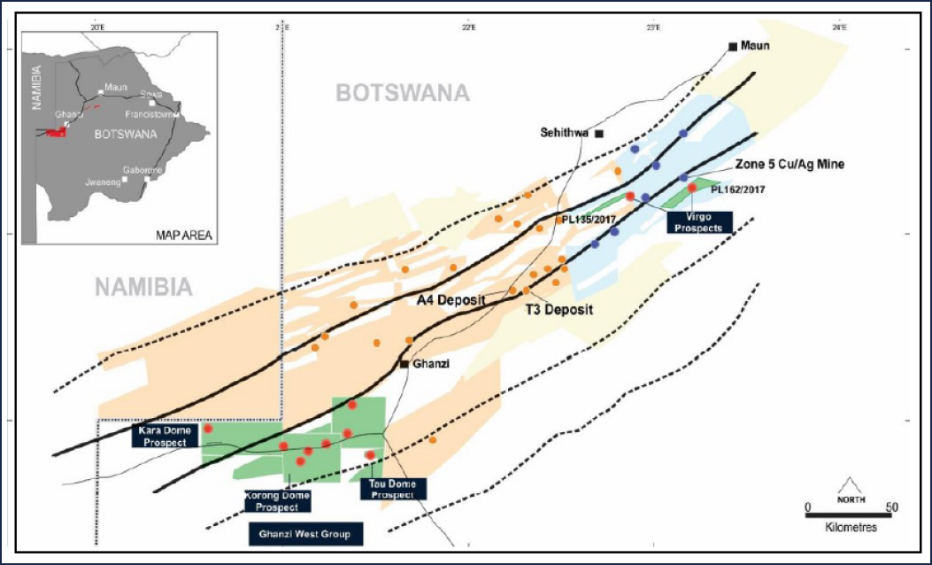
Map of The Virgo Copper Project and location in the Kalahari Copper Belt, Botswana
Tarouadji Lithium Project
Air Massif, Agadez Region, Niger
Geological Setting Favourable to Host Lithium Mineralisation
Overview
Landholding of 500km2 with historic lithium and tin anomalies.
Geological setting favourable to host lithium mineralisation, covering the one of region’s largest ring dyke structures and hosting identified pegmatitic intrusions.
Project located 70km east of the Company’s existing Agadez Uranium Project, providing a strategic logistical opportunity for exploration and development.
Initial exploration work carried out in Q3 CY2023, with results of rock chip samples released Q1 CY 2024, with best results of:
- Sample TAR15 - 1,079ppm Li, 1,295ppm Rb, 400ppm Sn
- Sample TAR16 - 1,139ppm Li, 1,346ppm Rb, 200ppm Sn
The rock chip sample results confirmed the historical available data.
Tarouadji Lithium Project complements existing uranium and copper asset portfolio, in line with the company’s clean-energy ambitions.
Map of ENRG Elements Tarouadji Project tenement and location in the Agadez region
Exploration Program - Next Steps
- Enhance the recently identified anomalism.
- Continued Geological mapping and a follow-up surface sampling to locate additional pegmatites.
- Investigate other historic geochemical anomalies to develop a broader sense of what the Tarouadji Ring structure has to offer.
“We are pleased by these results as they not only confirm the historic data but have also improved our understanding of the earlier anomalies. This is particularly pleasing as Tarouadji is a true greenfield prospect having little work or data completed to date to assist our exploration efforts. So far, we have only looked at a very small part of the permit and we can now advance our work with greater confidence, knowing that the historic samples have been validated.”
Caroline Keats
Managing Director
Geological Setting
- The tenement is located at the Agadez Region, at the southern end of the “Air Massif”, which covers over 100,000km2 and includes three geological units:
- Precambrian basement;
- Circular Palaeozoic sub volcanic ring structures; and
- Cenozoic volcanism.
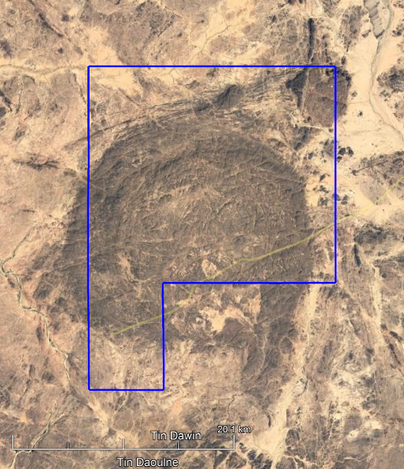
Topographic map of the ENRG Tarouadji Project in the Agadez Region
- The Precambrian basement has two subdivisions: a heterogeneous metamorphic sequence and a series of granitic intrusions. The Paleozoic unit consists of multiple anorogenic ring complexes that extend for about 1,500km and are dated from the Cambrian in the north to the Jurassic in the south. These ring-complexes are recognized as the largest ring dykes in the world with the tenement mostly covering the “Tarouadji-Type” ring structure that is composed of plutonic alkaline granites and biotite granitic rocks with identified pegmatitic intrusions.
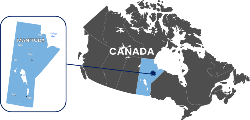
Manitoba Lithium Project
Manitoba, Canada
Geological Setting Favourable to Host Lithium Mineralisation
Overview
3 Mineral Exploration Licenses (Handle, Split and Unwin Lake) and 1 Pending Application (Beaver Hill Lake).
Landholding totalling ~500km2.
Historical evidence of pegmatite as either dykes, veins or swarms as identified in historic diamond drilling or exploration reports.
Manitoba hosts the world class “Tanco” LCT pegmatite (Lithium-Caesium-Tantalum) Mine located in eastern Manitoba.
Manitoba Lithium Project complements existing uranium, lithium and copper asset portfolio, in line with the company’s clean-energy ambitions.
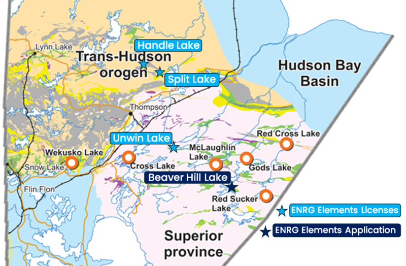
Map of ENRG Elements Manitoba Lithium Project licenses and location
Initial Exploration Program
- Company will conduct a detailed review of all historical reports including a comprehensive validation of all data.
- Where possible, geophysical data will be re-processed to assist in target generation in conjunction with geological interpretation and high-resolution satellite imagery.
- First pass field work once ground access can be achieved.
“Our step into Canada adds complementary energy opportunities to our current portfolio. Canada has been recognised as a very favourable Archaean and Proterozoic geological setting for the discovery of new and large-scale lithium deposits. We have high quality historic exploration data to assist in target generation and we plan to progress exploration activities on the ground in Manitoba following grant of the tenements.”
Caroline Keats
Managing Director
Handle Lake Project
- The license covers a total area of 74.30km2 and is located approximately 95kms north of Thompson, the largest city in northern Manitoba.
- Area lies within the Churchill Province in the Trans-Hudson Orogen.
- The area can be typified as a generally east-west trending Proterozoic greenstone-granite terrain.
- Historical exploration reports and drill logs available with pegmatite intersects.
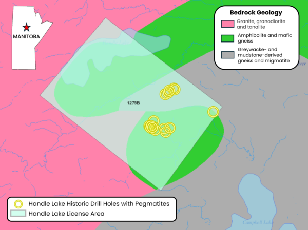
Handle Lake Project – Historic Drill Hole Locations with Identified Pegmatites
Split Lake Project
- The license covers an area of 76.09km2 and is located approximately 103 km north-east of Thompson, Manitoba and approximately 48km north-west of Split Lake, Manitoba.
- Area lies within the Churchill Structural Province with basement identified as the Early Proterozoic Pelletier Lake – Waskaiowaka Lake Greenstone Belt.
- Hosts large scale, northeast–southwest trending faults associated with the Trans Hudson Orogen.
- Historical exploration reports and drill logs available with pegmatite intersects.
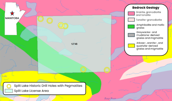
Split Lake Project – Historic Drill Hole Locations with Identified Pegmatites
Unwin Lake Project
- The license covers an area of 264.28km2, is located within the greenstone belt of northeastern Manitoba, approximately 97km southeast of Thompson.
- Area is situated in the Superior Province in an Archean granite-greenstone terrain.
- Area is considered to have a similar geological setting as the Tanco Mine area, located 518km to the south within the Superior Province.
- Historical exploration reports and drill logs available with pegmatite intersects.
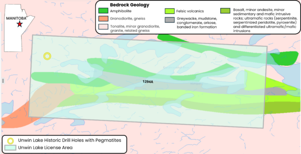
Unwin Lake Project – Historic Drill Hole Locations with Identified Pegmatites
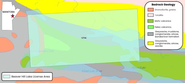
Beaver Hill Lake Project
- The application area covers ~87.7km2 and is situated in north-eastern Manitoba at the southern end of God’s Lake, 250kms southeast of Thompson.
- The area, which is considered to host a similar geological setting to the Tanco Mine, covers part of the Goose Lake greenstone belt.
- This Archean granite-greenstone belt is within the Gods Lake domain of the Superior Province.
- Historical exploration reports available.
Beaver Hill Lake Project Location